(a) Draw an outline map of Nigeria. On it, locate and name' (i) The Chad Basin. (ii) The Western Highlands; (iii) One important town in (a)(i) or (ii) above.
(b) Describe the geography of the Western Highlands under the following headings: (i) Relief: (ii) Economic activities:
(iii) Problems of development.
(b) Describe the geography of the Western Highlands under the following headings: (i) Relief: (ii) Economic activities:
(iii) Problems of development.
Take Free Practice Test On 2026 JAMB UTME, Post UTME, WAEC SSCE, GCE, NECO SSCE
Correct Answer: Option
Explanation:
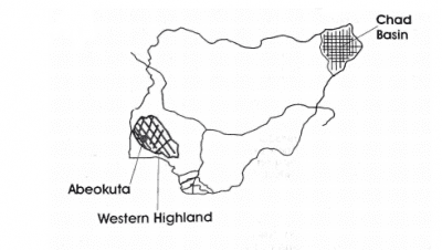
(b) Geography of Western Highlands of Nigeria:
(i) Relief: (1) Soil type is ferruginous.
(2) Some of the hills are steep-sided.
(3) Rock type is basement complex.
(4) Height ranges from 300-600m above sea level.
(5) Area also known as Yoruba plateau
(6) Made up of group of hills, e.g. Idanre, Apata, Epinmi and Kukuru hills.
(7) Some peaks are over 1000m, e.g. Idanre hills, Illesha hills, etc.
(ii) Economic activities
(1) Commercial activities.
(2) Tourism. (3) Lumbering (4) Quarrying.
(5) Industrial activities, e.g. textile, tobacco, rubber processing, etc.
(6) Local craft industries, e.g. tie and dye, basket weaving.
(7) Livestock rearing in the northern part due to the presence of grasslands.
(8) Mining, e.g. marble at Igbetti and gold at Ilesa.
(9) Farming of food crops, e.g. yam, cassava, etc.
(10) Farming of cash crops, e.g. cocoa, oil palm cola nut, etc.
(iii) Problems of development:
(1) High population with poor physical planning.
(2) Hilly relief constitutes problem to construction of buildings in some places.
(3) Soil erosion. (4) Land tenure system.
(5) Environmental pollution.
(6) Flooding along river valleys in urban areas. (7) Infertile, leached lateritic soils.
(8) High rural — urban migration leading to low labour force.